
My heart always skips a beat when I stumble on a piece of evidence that demonstrates that Italy has a quality-focused wine culture that is at least as old as France’s – perhaps much older. Let’s not forget that it was the Romans who introduced the novelty of systematic viticulture to the Gauls. That aside, I am talking about a piece of evidence that should silence those who claim that Italy’s quality wine history began only with the introduction of barriques and international varieties.
While we are witnessing the end of this short-lived period of wine modernism, the reality is very different, but only if one takes the historical context into account, something the majority of Italian wine producers often fail to do. In ignoring this, they perpetuate their self-inflicted inferiority complex while continuing to compare themselves, unfavourably most of the time, with France.
Flashback to September 2014: I am hunched over the beautifully handwritten catastro from 1678 in the bowels of the town hall of Gattinara (see this report), with records of tax levied on every single vineyard patch in the municipality. Recordings of tax levied on vineyard possessions in Gattinara go back at least to 1533 and what is striking is that it reveals a classification system avant la lettre. The best vineyards attracted a tax of 18 lira per seppatura (a square of 100 vines), while the least suitable paid only 6 lira. I thank Erling Astrup, who runs the historic Nervi estate and who made me discover these ancient documents. Incidentally, Gattinara was founded by the Romans, as witness the grid-like street pattern that persists in the historic centre today.
Alberto Pattono, in his excellent historical overview of Gattinara and its wines, His Excellency Gattinara (2013), explains that further tax was levied on the actual wines based on different levels of quality. Wine coming from the plain was taxed at the lowest level, followed by wine made from grapes from hill sites with a less than ideal exposition, while the best vineyards with a southerly exposition attracted the highest tax. In my opinion, the catastro could be considered a credible classification, not least because almost all of the vineyards mentioned in this ancient document managed to survive well into the 21st century in spite of the many disasters such as phylloxera, destructive hail (like the one in 1905 that wiped out whole swathes of vineyards) and the growing allure of industrialisation, which, after the Second World War, led to an exodus of the people who once tended the Gattinara vineyards. All these events reduced the original area of 600 ha (1,480 acres) to the current 94.5 ha.
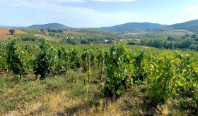
One could argue in favour of a classification of its best vineyards, but in general I found all the wines of Gattinara based on Nebbiolo (called Spanna here) to be admirably consistent and original. Stylistically they are very different from Barolo and Barbaresco, relying less on power and more on perfume and elegance. This makes them very approachable when young but, owing to their prominent acidity and fine tannins, they are capable of ageing gracefully for many years as well. Many Gattinaras are 100% Spanna, but the disciplinare, the official production rules, allow a maximum of 4% Vespolina and 6% Uva Rara. This reflects the current state of several old vineyards.
There was just one problem with this tiny Alto Piemonte jewel: it didn’t have a map. Anyone now bored by my regular banging on about the necessity of maps should stop here and read my tasting notes in a forthcoming article. I strongly believed Gattinara deserved one and that I, along with other wine lovers, needed one. A map with the precise location of each vineyard would anchor the wines firmly in their place of origin, playing a deciding role in their uniqueness. I decided to ask Italian’s maestro of vineyard mapping, Alessandro Masnaghetti, if he would be interested in the job. Luckily for both me and Gattinara, he was.
With one obstacle out of the way, the next was to convince the producers. That proved to be less plain sailing. What I did have from the beginning was the firm support of two producers who were willing to fund the entire project, but I believed that for the project to succeed, I would need to get all the producers on board. I needed a plenary meeting in which I could argue my case and show examples of Masnaghetti’s work. This is where the mayor of Gattinara, Daniele Baglione, and Umberto Stupenengo, who is responsible for the daily running of Gattinara, came in, sending out an invitation to the meeting at the town hall which took place in early February 2015. Italy’s producers are known to be fiercely independent and seemingly paranoid about what they perceive to be their competitors, but I was stunned to see that all of Gattinara’s producers were present on 2 February 2015.
While it was easy to show them the magnificence and relevance of the Masnaghetti maps (I had brought stacks of them along to prove my point), it was probably true that only an outsider without any vested interests could have managed to get their support, unanimous support in the event. Much later, when Masnaghetti and I actually embarked on the project, visiting each of the 14 producers, I was astonished to see an abundance of ancient, finely detailed, hand-drawn maps of Gattinara’s vineyards shown to us in the town hall rolled out on huge purpose-built tables. But until now the only modern ‘map’ we could rely on had been an aerial photograph of the Gattinara vineyards from the 1980s.
Now that producers had given their support to the plan (not least due to Stupenengo patiently reminding them of their individual commitment by email), a thornier issue was yet to be resolved: how to reach consensus on the financial side. Although not a vast amount of money was needed, the problem was much more about who would pay exactly what towards its realisation. Most of Gattinara’s producers have small, sometimes even tiny, holdings, while only three or so can lay claim to a vineyard area of 14 ha (35 acres) or more. In the end a quota based on the size of each estate was decided on, while the commune of Gattinara, strongly believing in the relevance of the map as a tourist tool, also made a considerable donation towards the project.
My involvement ended here, while Masnaghetti’s work began. With the help of Google Earth, the preliminary map was drawn up, which in itself is a huge work, but the real difficulty is to check its correctness. Google Earth allows you to see roughly the boundaries of vineyards as well as elevations, but it doesn’t give exact clues to minute but crucial details such as ownership, soil composition and exposition of the vineyards as well as their size and individual plots. In the first phase, this rudimentary map is checked against other maps and cartography obtained from the Gattinara town hall, which itself has no current map with this precise information, except for the aforementioned photograph.
To get your hands on these details you have to talk to each individual producer and check their vineyards as registered in the cadastre on the maps they must have to prove their lawful possession. A fascinating exchange with each of the 14 producers followed during visits to their estates. While their cadastre maps showed a faithful registration of their holdings, etymology, the changing of names and words of the ancient vineyards, turned out to create a fascinating conundrum.
One of the most challenging aspects of Masnagheti’s work is getting consensus on vineyard nomenclature. For example, when we visited the estate of Gian Carlo and Marco Petterino there was confusion about the name of the vineyard called Permolone, but spelled Permoloni on the photograph. The brothers told us that their grandfather had called the vineyard Permolone. Also, the Palfér vineyard, on the photo indicated as a separate vineyard, was never an independent plot according to Petterino, but was named as such because the road from the town leading up to Permolone ended there in a mule’s path which was so rocky and stony it had to be broken up with iron poles to broaden it. In spite of this historic information, it has not been indicated separately on the final map because according to several producers it is considered a continuation of Permolone. Also, Paride Iaretti, who has many parcels which are so tiny they are mere square metres rather than hectares, confirms that Palfér is, in actual fact, the northern continuation of Permolone.
Another interesting dilemma was Valferana, which we found to be spelled with either one or two ‘r’s, or as ‘Valferane’. The historic name appears to be Valferana and hence Masnaghetti decided in favour of this version. In the face of many opinions, you need to take a decision at some point and, needless to say, these decisions can be controversial, but in every case the historic name was given precedence. Valferana, incidentally, comes from Val Ferro, indicating that the soils here are high in iron.
One of the most distinct vineyards in Gattinara is Osso, extending over four ridges, of which the far eastern one is called Osso San Grato, a monopole made famous by single bottlings from the Antoniolo estate. It is considered a top cru, which Masnaghetti singled out on the map on the basis of this status as well as historical evidence given by old maps. One of the ridges is locally known as Sasso di l’Oss, which, in the future, may justify its own subzone, but for the moment specific support in the form of single-vineyard wines is lacking to add real gravitas to that potential claim. This may be something for the future.
Furthermore, what Masnaghetti originally identified as Marzola, a vineyard bordering Gattinara’s outskirts in the west, contains a parcel known as Donaghe. Historically it was a place with chestnut trees where the women of Gattinara used to gather, which is why it became known as Donaghe, from donna or woman.
The question arising was whether all of Donaghe should be considered a separate plot or included in Marzola. The issue is that when you have a tiny zone, such as Donaghe, it can lead to confusion, but it being a continuation of Marzola it was decided to include it in this vineyard. To complicate matters further, and according to Mauro Franchino, who has holdings here, in both zones plantings are on the increase, raising the additional question of how long a map remains accurate. In the end, both Masnaghetti and Franchino reasoned that if Donaghe is a historic name it should be preserved, so Masnaghetti came up with the future possibility of turning it into the subzone of Marzola-Donaghe. Sitting in Mauro Franchino’s kitchen, where the blinking red light of the washing machine made me return to reality, I suddenly wondered why anyone who has never heard of Gattinara would actually care about this map. Although it is clear to me that the region needs the map, it must be difficult for individual producers to understand this need.

Myriad and often unexpected issues, at least for me, had to be clarified during our meetings with each individual producer, with one detail that is easily overlooked but which I found memorable just because of that. Luca Caligaris, who runs the estate bearing his family’s surname, has a couple of tiny parcels mainly in two zones, Castelle and Osso. His youngest vines are 70 years old. He makes a Riserva only if there are enough grapes, which was the case in 2007 and 2012. They mainly come from Osso, where he has just planted a new parcel of vines which were not visible on Google Earth. Thanks to our meeting, they are now included to reflect as precisely as possible the current as well as future situation in Gattinara. The devil is in the detail.
The fact checking against historical information, often only by word-of-mouth and hence with a certain amount of inconsistency, is a literally endless process. The proof comes by going into the vineyards. It may sound so easy, but checking the map for truthfulness can be done only by ‘reading’ the landscape, a true work of art sustained by years of experience. While Alessandro was muttering ‘oh, it is like that’ or ‘this vineyard actually ends there’ while looking over rolling hills that seemed to hide parts of the vineyard area to the untrained eye, and was looking for vantage points while driving around, I was literally lost.
A huge help was the tower of the Castello of San Lorenzo, at roughly 600 m (1,970 ft) the region’s highest point overlooking the entire region and giving valuable clues as to where you actually are. But Masnaghetti was also registering and correcting the direction in which trellis systems run, knowing the exact direction of the compass without once checking. Some of this information can be discerned from traditional viticultural practices which dictate that vineyards should always be orientated towards the south. But this was not always that clear cut.

With all the visual information gathered, not helped much by the weather gods who gave us just one clear late afternoon sky and one the following early morning, allowing Alessandro to have an unobstructed view, he divided the area into ‘sectors’ or macrozones following the criteria of ‘visual homogeneity, ie that which the eye and the landscape suggests’, according to his words on the back of the printed map. I don’t have the experience to interpret a vineyard area in this way, but it makes total sense if you see the map itself. On the basis of natural valleys (visible in 3D on the back of the printed map), streams and elevations, and taking different soil types into account, he arrived at seven macrozones. These he has made accessible to the wine lover as well as the professional by dividing them into three 'itineraries' which take into account not only soil compositions, but also natural boundaries as well as vantage points on walks in the region. It literally gives you a bird’s eye view of Gattinara’s cru vineyards as well as a broader view of the entire area.
For the future the next step will be to identify the single vineyards of each producer, but this first huge effort of bringing it all together in a coherent map is already a gigantic step. I expect that for several producers the map did not go far enough in this aspect, but for a region which has never had a detailed delineation of its vineyards, the Masnaghetti map represents monumental progress, while at the same tine making every producer feel included in this effort. With many changes and developments continuously happening, this is undoubtedly the next step.
A cartographer’s job is never done.